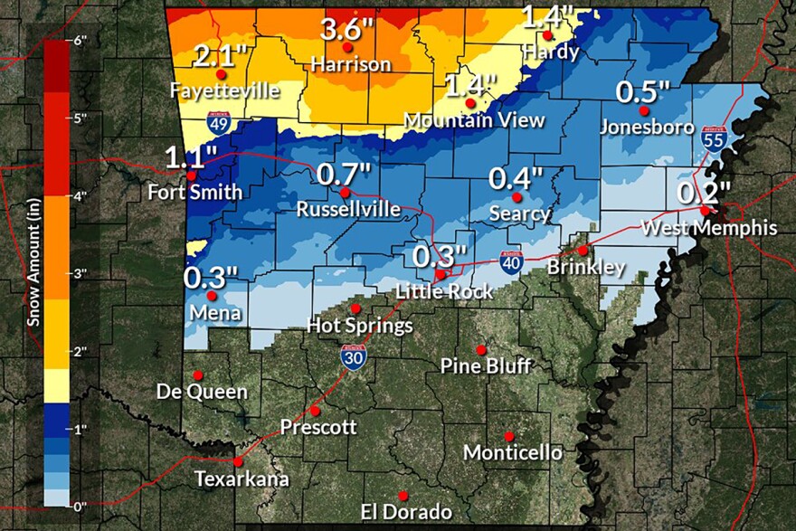
Arkansas is forecast to receive a mix of snow, sleet and freezing rain later this week with the potential for hazardous driving conditions.
The National Weather Service says rain is expected to begin on Tuesday, then a cold front will enter the state causing a gradually transition to winter weather on Wednesday. But forecasters say there is still uncertainty about the amount and types of precipitation, making it difficult to predict.
Meteorologist Thomas Jones says after the wind switches to the northwest and brings in colder air he expects to see “rain change to freezing rain and sleet across the north part of the state.”
Thursday morning, Jones predicts, is when the cooler air will dip into central Arkansas and possibly turn the rain into freezing rain.
Snow will likely be isolated to north Arkansas, changing into sleet and freezing rain as temperatures are warmer further south. Those in north-central Arkansas should look for possibly a tenth to a quarter-inch of freezing rain.
“With the freezing rain, mainly bridges and overpasses and things like that could become slick and can definitely make the commute for Thursday morning a bit dicey,” Jones said, adding that if people are able to work from home on Thursday they should.
He said the difficulty with predicting this winter weather comes from the variety of factors, adding that freezing rain could be especially hazardous.
“The snow adds up the fastest. Sleet creates a just solid layer of ice. [It] doesn’t typically disturb trees and powerlines too much, but then freezing rain will add up the slowest, as far as measuring," Jones said. "It has the most impacts: power outages, trees down, and black ice across bridges and overpasses.”
To best prepare, he suggests people in the areas expected to be impacted get any essential errands done before Wednesday evening and try to limit travel as much as possible.
The winter weather outlook is being monitored, Jones said, with more details to be fleshed out in the next 24 hours.


